Geospatial data types
Snowflake offers native support for geospatial features such as points, lines, and polygons on the Earth’s surface.
Tip
You can use the search optimization service to improve query performance. For details, see Search optimization service.
Data types
Snowflake provides the following data types for geospatial data:
- The GEOGRAPHY data type, which models Earth as though it were a perfect sphere.
- The GEOMETRY data type, which represents features in a planar (Euclidean, Cartesian) coordinate system.
GEOGRAPHY data type
The GEOGRAPHY data type follows the WGS 84 standard (spatial reference ID 4326; for details, see https://epsg.io/4326).
Points on the earth are represented as degrees of longitude (from -180 degrees to +180 degrees) and latitude (-90 to +90). Snowflake uses 14 decimal places to store GEOGRAPHY coordinates. When the data includes decimal places exceeding this limit, the coordinates are rounded to ensure compliance with the specified length constraint.
Altitude currently isn’t supported.
Line segments are interpreted as great circle arcs on the Earth’s surface.
Snowflake also provides geospatial functions that operate on the GEOGRAPHY data type.
If you have geospatial data — such as longitude and latitude data, WKT, WKB, GeoJSON, and so on — we suggest converting and storing the data in GEOGRAPHY columns, rather than keeping the data in their original formats in VARCHAR, VARIANT, or NUMBER columns. Storing your data in GEOGRAPHY columns can significantly improve the performance of queries that use geospatial functionality.
When the input to a geospatial function for the GEOGRAPHY data type represents a polygon, the starting point and ending point in the polygon must be the same. Otherwise, the function might return errors.
GEOMETRY data type
The GEOMETRY data type represents features in a planar (Euclidean, Cartesian) coordinate system.
The coordinates are represented as pairs of real numbers (x, y). Currently, only 2D coordinates are supported.
The units of the X and Y are determined by the spatial reference system (SRS) associated with the GEOMETRY object. The spatial reference system is identified by the spatial reference system identifier (SRID) number. Unless the SRID is provided when creating the GEOMETRY object or by calling ST_SETSRID, the SRID is 0.
Snowflake uses 14 decimal places to store GEOMETRY coordinates. When the data includes decimal places exceeding this limit, the coordinates are rounded to ensure compliance with the specified length constraint.
Snowflake provides a set of geospatial functions that operate on the GEOMETRY data type. For these functions:
- All functions assume planar coordinates, even if the geometry uses a non-planar SRS.
- The measurement functions (for example, ST_LENGTH) use the same units as the coordinate system.
- For functions that accept multiple GEOMETRY expressions as arguments (for example, ST_DISTANCE), the input expressions must be defined in the same SRS.
Geospatial input and output
The following sections cover the supported standard formats and object types when reading and writing geospatial data.
- Supported standard input and output formats
- Supported geospatial object types
- Specifying the output format for result sets
- Examples of inserting and querying GEOGRAPHY data
Supported standard input and output formats
The GEOGRAPHY and GEOMETRY data types support the following standard industry formats for input and output:
- Well-Known Text (WKT)
- Well-Known Binary (WKB)
- Extended WKT and WKB (EWKT and EWKB) (see the note on EWKT and EWKB handling)
- IETF GeoJSON (see the note on GeoJSON handling)
You might also find the following Open Geospatial Consortium’s Simple Feature Access references helpful:
Any departure from these standards is noted explicitly in the Snowflake documentation.
GeoJSON handling for GEOGRAPHY values
The WKT and WKB standards specify a format only. The semantics of WKT/WKB objects depend on the reference system (for example, a plane or a sphere).
The GeoJSON standard, on the other hand, specifies both a format and its semantics: GeoJSON points are explicitly WGS 84 coordinates, and GeoJSON line segments are planar edges (straight lines).
Contrary to that, the Snowflake GEOGRAPHY data type interprets all line segments, including those input from or output to GeoJSON format, as great circle arcs. In essence, Snowflake treats GeoJSON as JSON-formatted WKT with spherical semantics.
EWKT and EWKB handling for GEOGRAPHY values
EWKT and EWKB are non-standard formats introduced by PostGIS. They enhance the WKT and WKB formats by including a spatial reference system identifier (SRID), which specifies the coordinate reference system to use with the data. Snowflake currently supports only WGS84, which maps to SRID=4326.
By default, Snowflake issues an error if an EWKB or EWKT input value contains an SRID other than 4326. Conversely, all EWKB and EWKT output values have SRID=4326.
Supported geospatial object types
The GEOGRAPHY and GEOMETRY data types can store the following types of geospatial objects:
-
WKT / WKB / EWKT / EWKB / GeoJSON geospatial objects:
- Point
- MultiPoint
- LineString
- MultiLineString
- Polygon
- MultiPolygon
- GeometryCollection
-
These GeoJSON-specific geospatial objects:
- Feature
- FeatureCollection
Specifying the output format for result sets
The session parameters GEOGRAPHY_OUTPUT_FORMAT and GEOMETRY_OUTPUT_FORMAT control the rendering of GEOGRAPHY and GEOMETRY columns in result sets (respectively).
These parameters can have one of the following values:
| Parameter value | Description |
|---|---|
GeoJSON (default) | The GEOGRAPHY / GEOMETRY result is rendered as an OBJECT in GeoJSON format. |
WKT | The GEOGRAPHY / GEOMETRY result is rendered as a VARCHAR in WKT format. |
WKB | The GEOGRAPHY / GEOMETRY result is rendered as a BINARY in WKB format. |
EWKT | The GEOGRAPHY / GEOMETRY result is rendered as a VARCHAR in EWKT format. |
EWKB | The GEOGRAPHY / GEOMETRY result is rendered as a BINARY in EWKB format. |
For EWKT and EWKB, the SRID is always 4326 in the output. See EWKT and EWKB handling for GEOGRAPHY values.
This parameter affects all clients, including the Snowflake UI and the SnowSQL command-line client, as well as the JDBC, ODBC, Node.js, Python, and so on drivers and connectors.
For example, the JDBC Driver returns the following metadata for a GEOGRAPHY-typed result column (column i in this
example):
-
If
GEOGRAPHY_OUTPUT_FORMAT='GeoJSON'orGEOMETRY_OUTPUT_FORMAT='GeoJSON':ResultSetMetaData.getColumnType(i)returnsjava.sql.Types.VARCHAR.ResultSetMetaData.getColumnClassName(i)returns"java.lang.String".
-
If
GEOGRAPHY_OUTPUT_FORMAT='WKT'or'EWKT', or ifGEOMETRY_OUTPUT_FORMAT='WKT'or'EWKT':ResultSetMetaData.getColumnType(i)returnsjava.sql.Types.VARCHAR.ResultSetMetaData.getColumnClassName(i)returns"java.lang.String".
-
If
GEOGRAPHY_OUTPUT_FORMAT='WKB'or'EWKB', or ifGEOMETRY_OUTPUT_FORMAT='WKB'or'EWKB':ResultSetMetaData.getColumnType(i)returnsjava.sql.Types.BINARY.ResultSetMetaData.getColumnClassName(i)returns"[B"(array of byte).
Note
APIs for retrieving database-specific type names (getColumnTypeName in JDBC and the
SQL_DESC_TYPE_NAME descriptor in ODBC) always return GEOGRAPHY and GEOMETRY for the type name,
regardless of the values of the GEOGRAPHY_OUTPUT_FORMAT and GEOMETRY_OUTPUT_FORMAT parameters. For details, see:
- Snowflake-specific behavior in the JDBC Driver documentation.
- Retrieving results and information about results in the ODBC Driver documentation.
Examples of inserting and querying GEOGRAPHY data
The code below shows sample input and output for the GEOGRAPHY data type. Note the following:
- For the coordinates in WKT, EWKT, and GeoJSON, longitude appears before latitude (for example,
POINT(lon lat)).
- For the WKB and EWKB output, it is assumed that the BINARY_OUTPUT_FORMAT parameter
is set to
HEX(the default value for the parameter).
The following example creates a table with a GEOGRAPHY column, inserts data in WKT format, and returns the data in different output formats.
Using geospatial data in Snowflake
The following sections cover how to work with geospatial data in Snowflake.
- Understanding the effects of using different SRIDs with GEOMETRY
- Changing the spatial reference system (SRS) and SRID of a GEOMETRY object
- Performing DML operations on GEOGRAPHY and GEOMETRY columns
- Loading geospatial data from stages
- Using geospatial data with Java UDFs
- Using geospatial data with JavaScript UDFs
- Using geospatial data with Python UDFs
- Using GEOGRAPHY objects with H3
Understanding the effects of using different SRIDs with GEOMETRY
In a GEOMETRY column, you can insert objects that have different SRIDs. If the column contains more than one SRID, some of the important performance optimizations aren’t applied. This can result in slower queries, in particular when joining on a geospatial predicate.
Changing the spatial reference system (SRS) and SRID of a GEOMETRY object
To change the SRS and SRID of an existing GEOMETRY object, call the ST_TRANSFORM function,
passing in the new SRID. The function returns a new GEOMETRY object with the new SRID and the coordinates converted to use the
SRS. For example, to return a GEOMETRY object for geometry_expression that uses the SRS for SRID 32633, execute the following
statement:
If the original SRID isn’t set correctly in the existing GEOMETRY object, specify the original SRID as an additional argument.
For example, if geometry_expression is a GEOMETRY object that uses the SRID 4326, and you want to transform this to use the
SRID 28992, execute the following statement:
If a GEOMETRY object uses the correct coordinates for a SRS but has the wrong SRID, you can fix the SRID by calling the
ST_SETSRID function. For example, the following statement sets the SRID for
geometry_expression to 4326, while leaving the coordinates unchanged:
Performing DML operations on GEOGRAPHY and GEOMETRY columns
When a GEOGRAPHY or GEOMETRY column is the target of a DML operation (INSERT, COPY, UPDATE, MERGE, or CREATE TABLE AS…), the column’s source expression can be any of the following types:
- GEOGRAPHY or GEOMETRY : An expression of type GEOGRAPHY or GEOMETRY is usually the result of a parsing function, a constructor function, or an existing GEOGRAPHY or GEOMETRY column. For a complete list of supported functions and categories of functions, see Geospatial functions.
- VARCHAR: Interpreted as a WKT, WKB (in hex format), EWKT, EWKB (in hex format), or GeoJSON formatted string (see TO_GEOGRAPHY(VARCHAR)).
- BINARY: Interpreted as a WKB binary (see TO_GEOGRAPHY(BINARY) and TO_GEOMETRY(BINARY)).
- VARIANT: Interpreted as a GeoJSON object (see TO_GEOGRAPHY(VARIANT) and TO_GEOMETRY(VARIANT)).
Loading geospatial data from stages
You can load data from CSV or JSON/AVRO files in a stage directly (that is, without copy transforms) into a GEOGRAPHY column.
-
CSV: String values from the corresponding CSV column are parsed as GeoJSON, WKT, EWKT, WKB, or EWKB (see TO_GEOGRAPHY(VARCHAR)).
-
JSON/AVRO: The JSON values in the file are interpreted as GeoJSON (see TO_GEOGRAPHY(VARIANT)).
See also GeoJSON handling for GEOGRAPHY values.
Loading data from other file formats (Parquet, ORC, and so on) is possible through a COPY transform.
Using geospatial data with Java UDFs
Java UDFs allow the GEOGRAPHY type as an argument and as a return value. See SQL-Java Data Type Mappings and Passing a GEOGRAPHY value to an in-line Java UDF for details.
Using geospatial data with JavaScript UDFs
JavaScript UDFs allow the GEOGRAPHY or GEOMETRY type as an argument and as a return value.
If a JavaScript UDF has an argument of type GEOGRAPHY or GEOMETRY, that argument is visible as a JSON object in GeoJSON format inside the UDF body.
If a JavaScript UDF returns GEOGRAPHY or GEOMETRY, the UDF body is expected to return a JSON object in GeoJSON format.
For example, these two JavaScript UDFs are roughly equivalent to the built-in functions ST_X and ST_MAKEPOINT:
Using geospatial data with Python UDFs
Python UDFs allow the GEOGRAPHY and GEOMETRY types as arguments and as return values.
If a Python UDF has an argument of type GEOGRAPHY or GEOMETRY, that argument is represented as a
GeoJSON object, which is converted to a Python dict object inside the UDF body.
If a Python UDF returns GEOGRAPHY or GEOMETRY, the UDF body is expected to return a Python dict object
that complies with the structure of GeoJSON.
For example, this Python UDF returns the number of distinct geometries that constitute a composite GEOGRAPHY type:
Check Snowflake Labs for more samples of Python UDFs. Some of them enable complex spatial manipulations or simplify data ingestion. For example, this UDF allows reading formats that aren’t supported natively, such as Shapefiles (.SHP), TAB, KML, GPKG, and others.
Note
The code samples in Snowflake Labs are intended solely for reference and educational purposes. These code samples aren’t covered by any Service Level Agreement.
Using GEOGRAPHY objects with H3
H3_ is a hierarchical geospatial index that partitions
the world into hexagonal cells in a discrete global grid system.
Snowflake provides SQL functions that enable you to use H3 with GEOGRAPHY objects. You can use these functions to:
- Get the H3 cell ID (index) for a GEOGRAPHY object that represents a Point (and vice versa).
- Get the IDs of the minimal set of H3 cells that cover a GEOGRAPHY object.
- Get the IDs of the H3 cells that have centroids within a GEOGRAPHY object that represents a Polygon.
- Get the GEOGRAPHY object that represents the boundary of an H3 cell.
- Get the parents and children of a given H3 cell.
- Get the longitude and latitude of the centroid of an H3 cell (and vice versa).
- Get the resolution of an H3 cell.
- Get the hexadecimal representation of an H3 cell ID (and vice versa).
For more information about these functions, see Geospatial functions.
Choosing the geospatial data type to use (GEOGRAPHY or GEOMETRY)
The next sections explain the differences between the GEOGRAPHY and GEOMETRY data types:
- Understanding the differences between GEOGRAPHY and GEOMETRY
- Examples comparing the GEOGRAPHY and GEOMETRY data types
- Understanding the differences in input data validation
Understanding the differences between GEOGRAPHY and GEOMETRY
Although both the GEOGRAPHY and GEOMETRY data types define geospatial features, the types use different models. The following table summarizes the differences.
| GEOGRAPHY data type | GEOMETRY data type |
|---|---|
|
|
Examples comparing the GEOGRAPHY and GEOMETRY data types
The following examples compare the output of the geospatial functions when using the GEOGRAPHY and GEOMETRY data types as input.
Example 1: Querying the distance between Berlin and San Francisco
The following table compares the output of ST_DISTANCE for GEOGRAPHY types and GEOMETRY types:
| ST_DISTANCE using GEOGRAPHY input | ST_DISTANCE using GEOMETRY input |
|---|---|
As shown in the example above:
- With GEOGRAPHY input values, the input coordinates are in degrees, and the output value is in meters. (The result is 9,182 km.)
- With GEOMETRY input values, the input coordinates and output value are degrees. (The result is 136.208 degrees.)
Example 2: Querying the area of Germany
The following table compares the output of ST_AREA for GEOGRAPHY types and GEOMETRY types:
| ST_AREA using GEOGRAPHY input | ST_AREA using GEOMETRY input |
|---|---|
As shown in the example above:
- With GEOGRAPHY input values, the input coordinates are in degrees, the output value is in square meters. The result is 356,379 km^2.
- With GEOMETRY input values, the input coordinates are in degrees, and the output value is in square degrees. The result is 45.930 square degrees.
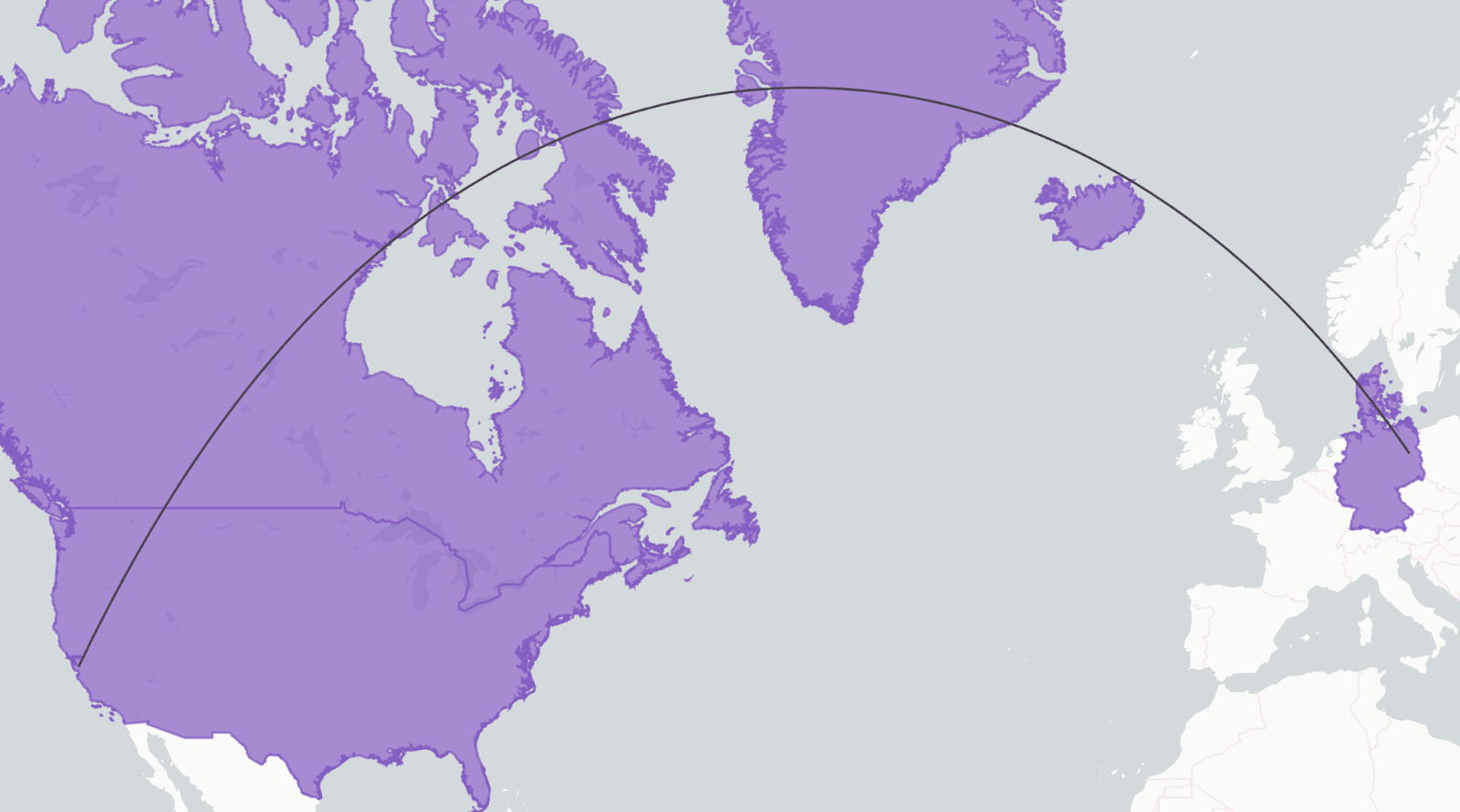
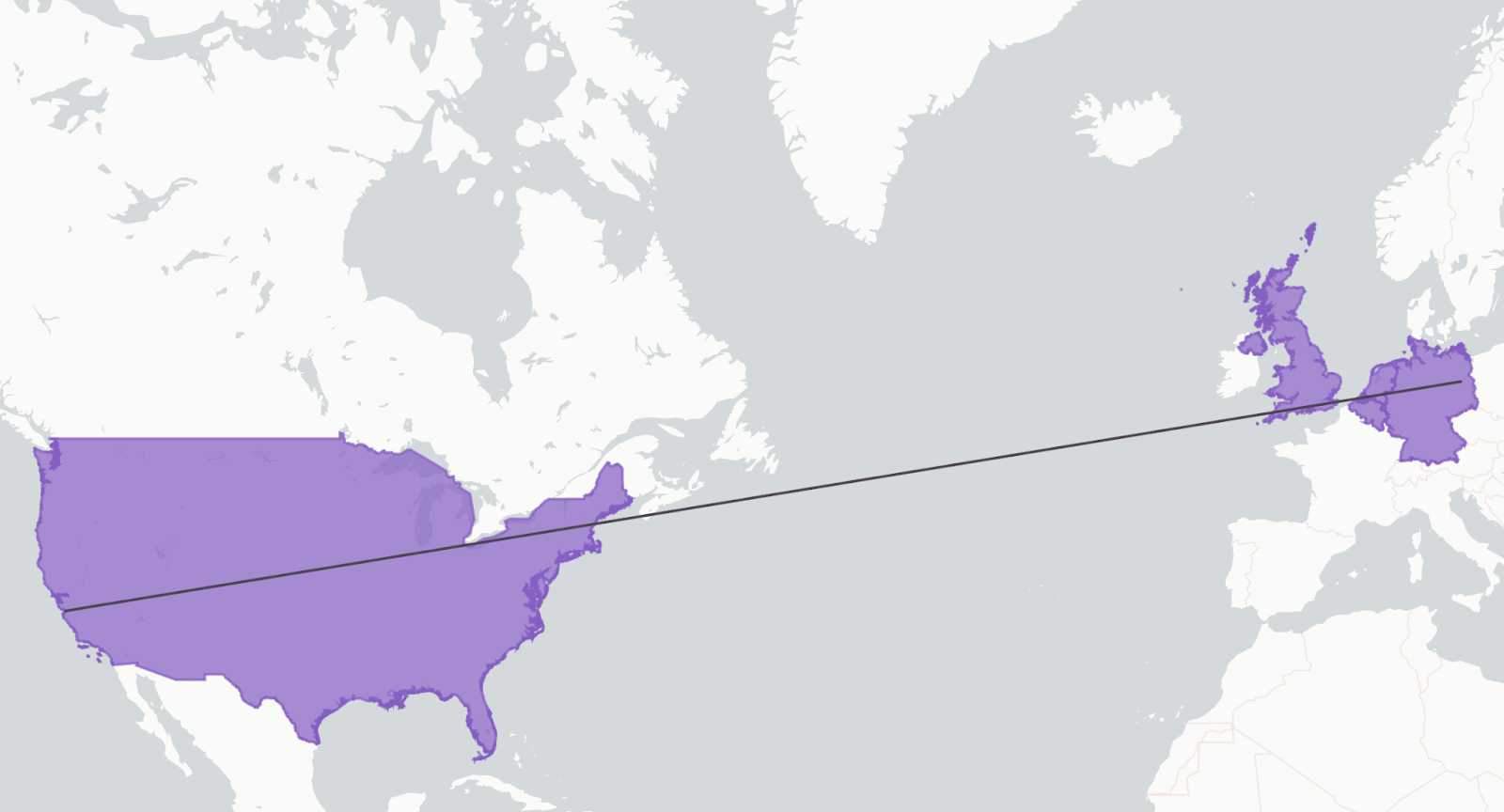
Example 3: Querying the names of countries overlapping the line from Berlin to San Francisco
The following table compares the output of ST_INTERSECTS for GEOGRAPHY types and GEOMETRY types:
| ST_INTERSECTS using GEOGRAPHY input | ST_INTERSECTS using GEOMETRY input |
|---|---|
 |  |
Understanding the differences in input data validation
To create a GEOMETRY or GEOGRAPHY object for an input shape, you must use a shape that is well-formed and valid, according to the OGC rules for Simple Features. The next sections explain how the validity of input data differs between GEOMETRY and GEOGRAPHY.
A shape can be valid GEOGRAPHY but invalid GEOMETRY
A given shape can be a valid GEOGRAPHY object but an invalid GEOMETRY object, and vice versa.
For example, self-intersecting polygons are disallowed by the OGC rules. A given set of points might define edges that intersect in the Cartesian domain but not on a sphere. Consider the following polygon:
In the Cartesian domain, this polygon degrades to a line and, as a result, is invalid.
However, on a sphere, this same polygon doesn’t intersect itself and is valid:
Conversion and constructor functions handle validation differently
When the input data is invalid, the GEOMETRY and GEOGRAPHY functions handle validation in different ways:
-
Some of the functions for constructing and converting to GEOGRAPHY objects might attempt to repair the shape to handle problems such as unclosed loops, spikes, cuts, and self-intersecting loops in polygons. For example, when either the TO_GEOGRAPHY function or the ST_MAKEPOLYGON function is used to construct a polygon, the function corrects the orientation of the loop to prevent the creation of polygons that span more than half of the globe. However, the ST_MAKEPOLYGONORIENTED function doesn’t attempt to correct the orientation of the loop.
If the function is successful in repairing the shape, the function returns a GEOGRAPHY object.
-
The functions for constructing and converting to GEOMETRY objects (for example, TO_GEOMETRY) don’t support the ability to repair the shape.
Converting between GEOGRAPHY and GEOMETRY
Snowflake supports converting from a GEOGRAPHY object to a GEOMETRY object (and vice versa). Snowflake also supports transformations of objects that use different spatial reference systems (SRS).
The following example converts a GEOGRAPHY object that represents a point to a GEOMETRY object with the SRID 0:
To set the SRID of the new GEOMETRY object, pass the SRID as an argument to the constructor function. For example:
If you need to set the SRID of an existing GEOMETRY object, see Changing the spatial reference system (SRS) and SRID of a GEOMETRY object.
Automatic performance optimizations for queries with geospatial predicates
Snowflake automatically implements the following performance optimizations for queries with geospatial predicates:
GeoJoin
GeoJoin is a Snowflake query optimization feature for geospatial joins. It’s a specialized join rewrite optimization that improves performance when joining tables based on predicates that call geospatial functions, such as ST_INTERSECTS, ST_CONTAINS, ST_DWITHIN, and so on. For example, a GeoJoin might be used to find all stores within specific geographic regions.
GeoJoin has the following characteristics:
- Automatically optimizes queries that join tables that use geospatial functions.
- Performs spatial overlap analysis between geographic datasets.
The GeoJoin optimization is triggered automatically by Snowflake’s query optimizer when it detects appropriate geospatial join patterns in your SQL queries. No additional configuration is required to benefit from improved performance.
Geospatial pruning for GEOMETRY predicates
Snowflake can improve the performance of some queries that filter on a GEOMETRY column by pruning micro-partitions that can’t contain matching rows. This optimization uses bounding-box metadata stored with GEOMETRY values to avoid scanning data that is guaranteed not to satisfy the predicate. That is, Snowflake skips micro-partitions whose stored bounding-box metadata don’t intersect the bounding box of a constant geometry in your filter.
Snowflake performs this optimization automatically, and no additional configuration is required to benefit from improved performance.
Predicates that can benefit from geospatial pruning
Pruning is designed for filter predicates on a GEOMETRY column where one side is a constant geometry, such as a literal or constant-foldable expression. For example:
ST_INTERSECTS(geom_col, <constant_geometry>)ST_CONTAINS(geom_col, <constant_geometry>)ST_COVERS(geom_col, <constant_geometry>)ST_COVEREDBY(geom_col, <constant_geometry>)ST_WITHIN(geom_col, <constant_geometry>)
These are the specific types of predicates that benefit from file-level pruning that uses bounding boxes.
How geospatial pruning works
A GEOMETRY value is stored with metadata that includes the following items:
- A bounding box (xmin, ymin, xmax, ymax)
- An SRID value
Snowflake uses file-level bounding-box metadata as the primary signal for pruning.
Snowflake pre-checks micro-partitions for bounding-box intersections before evaluating the exact geometry predicate. If the metadata indicates that no bounding-box overlap is possible, the micro-partitions can be skipped.
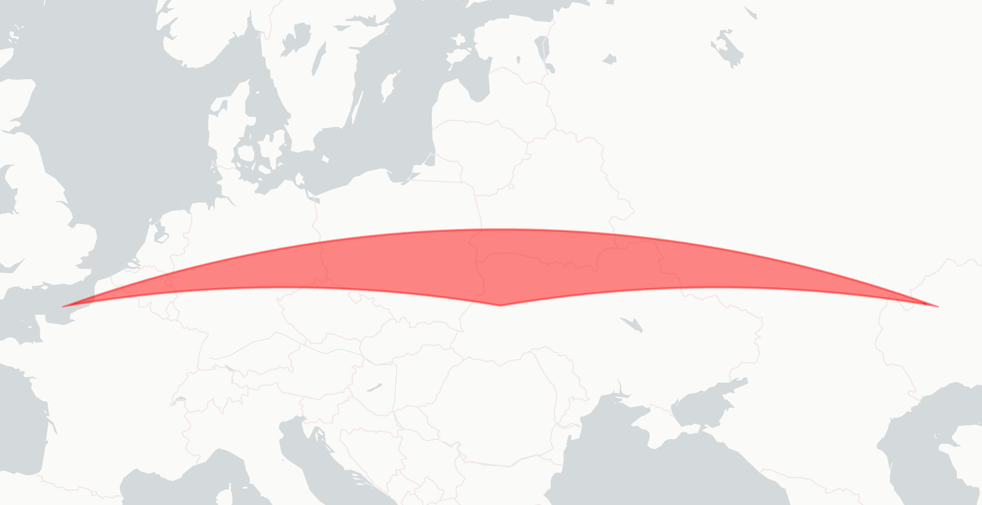
The following illustration shows a bounding-box line with two intersecting shapes and two non-intersecting shapes:
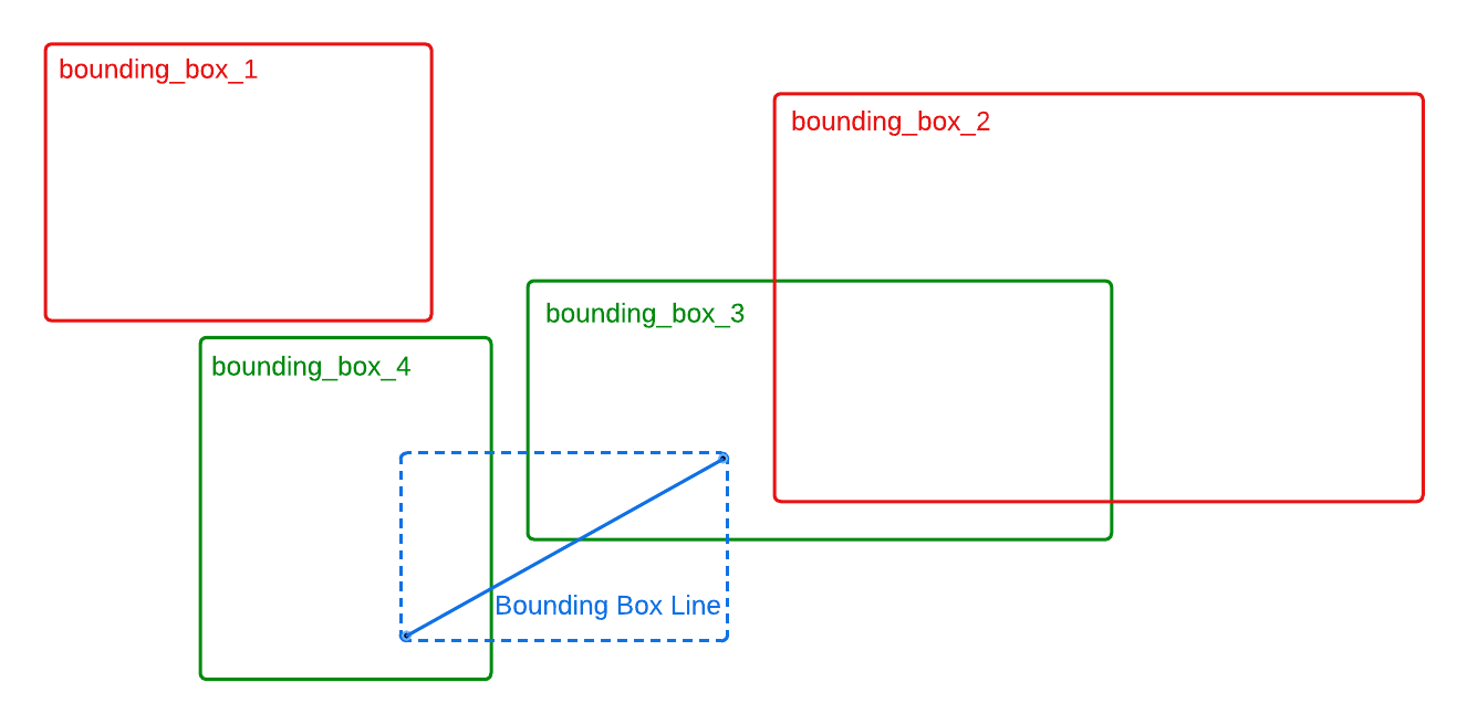
The illustration shows a geospatial query that is similar to the following example:
For a bounding box that is specified from the geospatial constant (shown in blue), only the micro-partitions that correspond with bounding boxes that overlap the bounding-box line (shown in green) are scanned. Micro-partitions that correspond with bounding boxes that don’t overlap (shown in red) are pruned.
SRID behavior
Spatial predicates in Snowflake are SRID-sensitive. Therefore, mixing incompatible SRIDs in the same column might return incorrect results. For the best results and deterministic behavior, keep SRIDs consistent within a GEOMETRY column, which is also the common real-world pattern.
Geospatial pruning for Iceberg tables
For Iceberg GEOMETRY columns, Snowflake tries to use the bounding-box metadata for geospatial pruning, the same way it does for GEOMETRY columns in standard Snowflake tables. If the necessary statistics are present in the underlying Iceberg metadata, the same pruning logic applies without modification.
Other performance considerations for geospatial pruning
Geospatial pruning works best when the data layout allows Snowflake to skip large ranges of micro-partitions. If rows with similar locations are spread across many micro-partitions, Snowflake might need to scan a large portion of the table, even when pruning is used.
Clustering by location can improve pruning efficiency. When you cluster rows by a spatial key derived from your GEOMETRY column, objects that are near each other are more likely to be stored in the same micro-partitions. As a result, spatial filters, such as ST_INTERSECTS or ST_CONTAINS with a constant geometry, can prune more micro-partitions and read less data.
Follow these best practices to optimize geospatial pruning:
- Cluster by a discretized spatial index, such as H3 or geohash, computed from a representative point of the geometry, such as the centroid. Use a resolution appropriate for your query window sizes.
- If your geometries are large, such as polygons that cover wide areas, consider clustering by multiple keys to reduce over-clustering and improve selectivity. For example, cluster by H3 at two resolutions or a coarse grid key plus a finer grid key. For datasets with a dominant query pattern — for example, “within a city” or “within a tile” — choose a clustering key that aligns with that pattern.
The following example clusters a table by a GEOMETRY column that contains points:
The following example clusters a table by a GEOMETRY column that contains LineStrings and Polygons:
Note
- Clustering doesn’t change query results. It changes how data is organized on storage. The benefits of clustering depend on data distribution, table size, and query patterns.
- You can monitor pruning effectiveness by comparing bytes scanned and micro-partitions scanned before and after clustering.
Limitations for geospatial pruning
The following limitations apply to geospatial pruning:
-
It applies only to GEOMETRY (planar) predicates.
To prune GEOGRAPHY predicates, use search optimization.
-
It applies only when one predicate argument is a constant.
If both predicate arguments are columns (for example,
ST_INTERSECTS(a.geom, b.geom)), this optimization doesn’t apply. For such cases, GeoJoin might be used.
Specifying how invalid geospatial shapes are handled
By default, when you use a geospatial conversion function to convert data in a supported input format to a GEOGRAPHY or GEOMETRY object, the function does the following:
- The function attempts to validate the shape in the input data.
- The function determines if the shape is valid according to the Open Geospatial Consortium’s Simple Feature Access / Common Architecture standard.
- If the shape is invalid, the function attempts to repair the data (for example, fixing polygons by closing the rings).
- If the shape is still invalid after the repairs, the function reports an error and doesn’t create the GEOGRAPHY or GEOMETRY object. (For the TRY_* functions, the functions return NULL, rather than reporting an error.)
With this feature, you have more control over the validation and repair process. You can:
- Allow these conversion functions to create GEOGRAPHY and GEOMETRY objects for invalid shapes.
- Determine if the shape for a GEOGRAPHY or GEOMETRY object is invalid.
Understanding the effects of invalid shapes on geospatial functions
Different geospatial functions have different effects when you pass in a GEOGRAPHY or GEOMETRY object for an invalid shape.
Effects on GEOMETRY objects
For GEOMETRY objects:
-
The following functions return results based on the original invalid shape:
-
The following functions validate the shape and fail with an error if the shape is invalid:
Effects on GEOGRAPHY objects
For GEOGRAPHY objects:
-
The following functions return results based on the original invalid shape:
-
The following functions validate the shape and fail with an error if the shape is invalid:
-
The following functions return NULL if it isn’t possible to compute the value:
Working with invalid shapes
The next sections explain how to allow functions to create invalid shapes and how to determine if a GEOGRAPHY or GEOMETRY object represents an invalid or repaired shape.
Allowing conversion functions to create invalid shapes
To allow the following conversion functions to create invalid geospatial objects, pass TRUE for the second argument
(allowInvalid):
By default, the allowInvalid argument is FALSE.
When you pass TRUE for the allowInvalid argument, the conversion function returns a GEOGRAPHY or GEOMETRY
object, even when the input shape is invalid and can’t be repaired successfully.
For example, the following input shape is a LineString that consists of the same two Points. Passing TRUE for the
allowInvalid argument returns a GEOMETRY object that represents an invalid shape:
Determining if a shape is invalid
To determine if a GEOGRAPHY or GEOMETRY object is invalid, call the ST_ISVALID function.
The following example checks if an object is valid: